
Understanding Your Property Survey and What It Means for Your Land
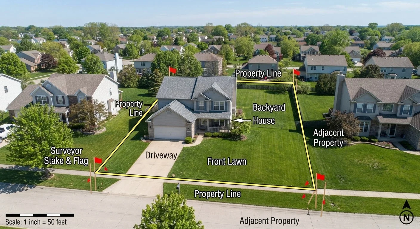
Photo credit: ResultsPoint.net | Find The Required Information
In this article
What a property survey shows, when you need one, and how boundary lines affect what you can build, plant, or fence.
Key Takeaways
- A property survey legally defines where your land starts and stops.
- Surveys reveal easements, encroachments, and setback lines that affect what you can build.
- Lenders and title insurers often require a survey at closing, but requirements vary by state.
- An outdated survey may not reflect additions, fences, or neighbor changes made since it was conducted.
- Boundary disputes with neighbors are far easier to resolve when you have a current, recorded survey.
What a Property Survey Actually Shows
A property survey is more than a drawing — it is a legally binding document that defines exactly what you own. When a licensed surveyor visits your property, they research deed records, plat maps, and historical documents, then physically measure the land and place or confirm boundary markers (often metal stakes or pins) at each corner.
The resulting plat map shows:
- Boundary lines — the precise legal edges of your parcel
- Dimensions and acreage — total size and the length of each boundary segment
- Easements — strips where utilities, municipalities, or neighbors have legal access rights
- Encroachments — structures or improvements that cross a boundary line, either yours onto a neighbor's land or theirs onto yours
- Setback lines — minimum distances from the boundary within which structures generally cannot be built, typically set by local zoning ordinances
- Existing structures — the location of your home, garage, and other improvements relative to the boundaries
Understanding these elements matters well beyond closing day. As noted in a broader look at long-term property ownership, your legal and physical obligations begin at your boundary lines and don't disappear once the mortgage paperwork is signed.
~36%
Homeowners unaware of their exact boundary lines
Industry surveys of homeowners suggest roughly a third are uncertain where their legal property lines actually fall, often relying on fences or landscaping as informal guides.
Varies by state
Survey requirements at mortgage closing
Some states and lenders require a current survey as a condition of closing; others accept title insurance in lieu of one, making it important to check your state's norms early in the process.
When You Need a New or Updated Survey
Surveys don't expire automatically, but their usefulness fades when circumstances change. You should strongly consider ordering a current survey in several situations:
- Before buying a home — particularly if the existing survey is more than a few years old or if the property has had additions or fencing installed since it was conducted
- Before adding a structure — fences, sheds, decks, pools, and room additions all need to respect setback requirements; building in the wrong location can trigger costly removal orders
- During a boundary dispute — if you and a neighbor disagree about where the property line runs, a current survey is the clearest way to establish the legal answer
- Before major landscaping — planting trees or installing irrigation near property edges can create future conflict if the boundary isn't confirmed first
If you're planning to garden close to the property edge, it's worth confirming your boundaries before you dig. Knowing your exact lot lines pairs naturally with other yard planning steps, like understanding sunlight patterns across your yard.
Check for Survey Pins Before You Dig
Before breaking ground on any project near your lot lines, look for existing survey pins — small metal stakes typically driven flush with the ground at property corners. A metal detector can help locate buried pins. If pins are missing or unclear, have a licensed surveyor re-establish them before proceeding. This small step can prevent costly mistakes and neighbor disputes.
How Surveys Affect What You Can Build or Plant
Your survey interacts directly with local zoning rules and deed restrictions to determine what's actually permitted on your land. Setback lines — shown on the plat — tell you how close to each boundary line a structure can be placed. These aren't guidelines; violating a setback can result in a stop-work order, fines, or a requirement to move the structure.
Easements carry their own restrictions. A utility easement along the back of your lot may prohibit permanent structures, fences of certain heights, or deep-rooted trees within that strip — even though the land is legally yours. Before installing a fence or planting a row of shrubs, check whether any easements run through that area.
Zoning ordinances layer on top of survey information. Your survey tells you where your land is; zoning tells you what you're allowed to do with it. The two work together. For a deeper look at those land-use rules, see how zoning laws shape your property rights.
Easements Are Not Always Obvious
Utility easements, drainage easements, and access easements are recorded in public documents but may not be visible on the ground. A neighbor's right-of-way or a municipality's drainage corridor can run through your yard without any physical marker. Always review easement information on your plat and in your title commitment before planning any improvements near the edges of your property.
Surveys vs. Home Inspections: Two Different Documents
Buyers sometimes confuse property surveys with home inspections — they are entirely separate. A home inspection covers the physical condition of the structure — the roof, foundation, systems, and components. A survey covers the land itself and where it sits in relation to neighboring parcels.
Neither document substitutes for the other. You can have a structurally sound home sitting partially on the wrong parcel, or a perfectly clear boundary with a house full of deferred maintenance. Both pieces of information matter to a complete picture of what you're buying and owning.
Frequently Asked Questions

Author
Real Estate Basics Editorial Team
Real Estate Basics Editorial Team is the collective byline for our editorial team and contributor network. Articles published under this byline or an editorial pen name are researched, written, and reviewed according to our editorial standards for clarity, consistency, and independence before publication.
View all articles →